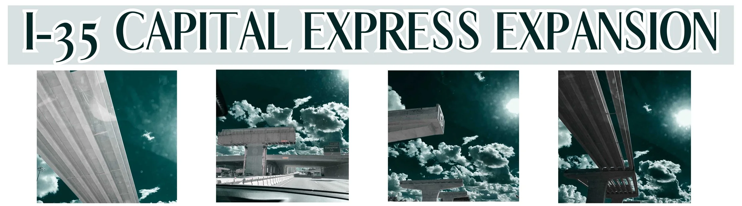
I-35 Central Austin Expansion (CapEx Central) - Project Overview and Timeline
The Texas Department of Transportation (TxDOT) is moving forward with the I-35 Capital Express Central project in Austin, largely adhering to the plans outlined in February 2024. Here’s the latest:
• Project Initiation: TxDOT broke ground on the $4.5 billion expansion in late October 2024.
• Caps and Stitches Funding: The City of Austin is evaluating funding options for the proposed “caps” over the sunken highway sections. Initially estimated at $900 million, recent projections have escalated to $1.4 billion. In March 2024, the city secured a $105.2 million federal grant to support this initiative. City Council has until March 2025 to decide on committing additional funds.
• Construction Timeline: The project is expected to span approximately nine years, with completion anticipated by 2032.

While the core elements of the project remain consistent with earlier plans, the significant increase in costs for the caps and stitches is a notable development. The City Council’s forthcoming decisions on funding will be crucial in determining the project’s final scope and design.
Install "caps" covering parts of the sunken highway — essentially creating an I-35 tunnel through downtown Austin — but only if Austin and the University of Texas foot the bill. The cost for the city alone could reach close to $900 million, not including tens of millions of dollars in annual maintenance expenses.
Narrow the main lanes from 12 feet wide to 11 feet.
Build at least 14 widened east-west vehicle bridges and at least seven stand-alone pedestrian bridges.
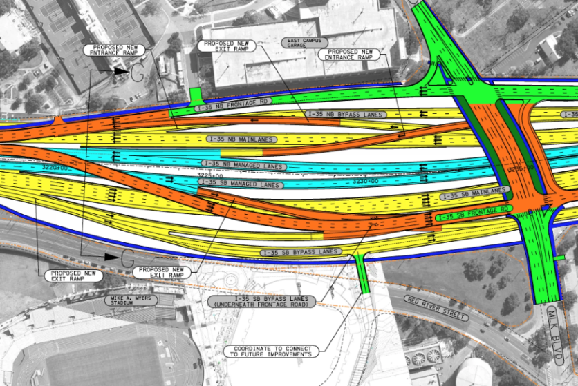
Construct larger interchanges at Riverside Drive and Airport Boulevard.
Eliminate the car crossing at Woodland Avenue.
Make north- and southbound frontage roads run side-by-side through downtown and much of the UT area.
Add more than 20 miles of "shared-use paths," which are basically 8-to-10-feet-wide sidewalks that often include a 2-foot-wide curb.
TxDOT says it will:
Build two extra "managed lanes" in each direction from Ben White Boulevard to U.S. 290 East. The managed lanes — in this case, high-occupancy vehicle (HOV) lanes — would be restricted to first responders, public transit vehicles and cars or trucks with more than one person inside. Local and state police would be responsible for enforcing the vehicle occupancy minimums.
Tear down the upper decks that run from Manor Road to Airport Boulevard.
Sink the main lanes 30-40 feet below ground level from Holly Street to Airport Boulevard.
I-35 will grow from 16 to 22 lanes in one section of downtown Austin.
Adding Lanes - The Plan
February 2025 Update:
The Texas Department of Transportation is advancing a $630 million project to transform the Lady Bird Lake bridge along I-35. This phase includes adding high-occupancy vehicle (HOV) lanes, a new interchange at Riverside Drive, a pedestrian-only bridge at Woodland Avenue, and enhanced bike and pedestrian paths.
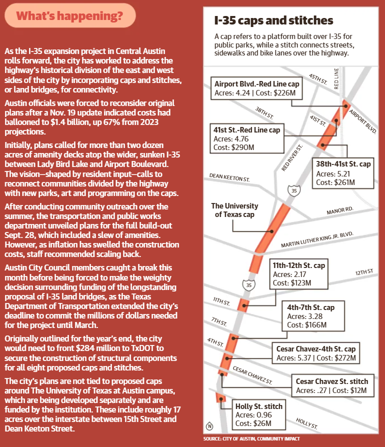
CAP AND STITCH
UT System Project:
• The University of Texas Board of Regents approved $106 million to build highway caps between 15th Street and Dean Keaton Street.
• These caps aim to connect the university campus with areas east of I-35.
• The project will generate revenue through future buildings and medical facilities.
City of Austin Project:
• Separate from UT’s project, the city plans to build caps at eight locations between Holly Street and Airport Boulevard.
• Proposed designs feature elevated walkways, outdoor dining spaces, and promenades.
• The estimated cost of the city project has risen to $1.4 billion, an increase of 50-80% from initial estimates due to added elements.
Funding and Approval Updates:
• City Council is considering six scaled scenarios for the project based on funding and community input.
• A $41 million loan from the State Infrastructure Bank is being reviewed to cover design fees.
• $105 million in federal funding has been secured for the section between Cesar Chavez and 4th Street, requiring a $45 million match from the city.
• Currently, only this section has funding for the cap deck itself.
Delays and Timeline:
• A City Council vote, originally scheduled, was delayed due to TxDOT contract issues.
• The final decision on moving forward with the project is expected in spring, with a March deadline.
Controversary

Costs soar for public spaces across I-35
With three major interstate expansion projects underway—the most recent breaking ground in late October on a stretch of I-35 in the heart of Austin—city staff are weighing options to minimize the effects of roadway construction.
After a hike in costs and a newly extended deadline to fund infrastructure that would support these caps, City Council members are evaluating several financial options, likely to impact taxpayers. — Community Impact
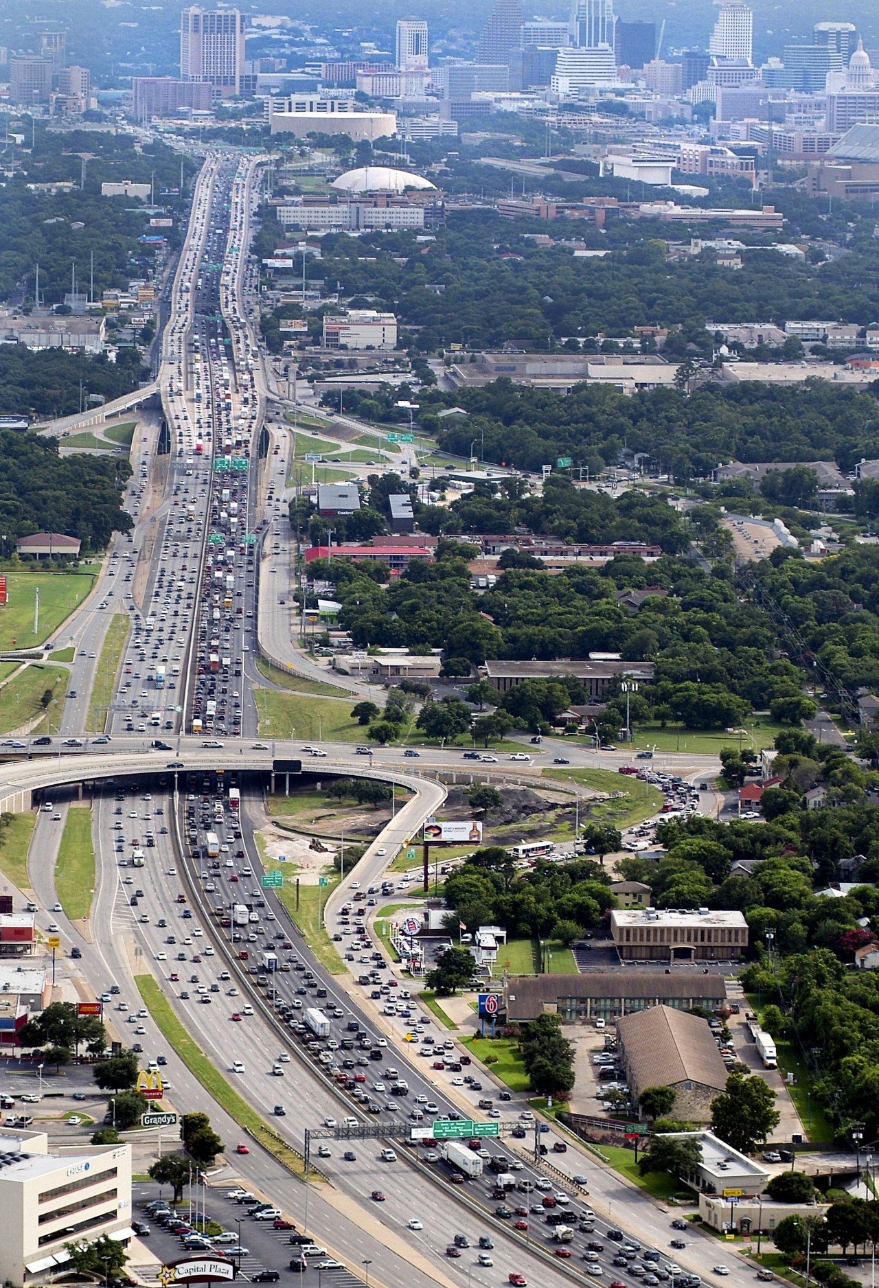
Over the next decade, the Texas Department of Transportation will be reworking and widening an 8-mile stretch of I-35 through the city.
TxDOT's $4.5 billion Capital Express Central will remove I-35's raised lanes, lower the road, add new lanes, and improve east-west highway crossings for vehicles, pedestrians and cyclists. State officials formally broke ground on the project running between Hwy. 71 to the south and US 290 to the north on Oct. 30.
— Community Impact
Austin's $1.4B plan to build amenity decks on I-35 could be scaled back
What's happening

Construction of Austin's caps and stitches around downtown and the Hancock and Cherrywood neighborhoods was estimated to cost nearly $900 million earlier this year. The plan is not tied to proposed caps around The University of Texas at Austin campus, which are being developed separately and would be funded by the institution.
City officials are now nearing a deadline to decide where future caps and stitches will be placed. TxDOT will build the highway with room for the features the city desires, but Austin must commit to paying for the roadway infrastructure needed for those decks before the end of the year.
Given a total price tag that's now estimated at $1.4 billion and funding uncertainty, city transportation staff are now recommending a significantly scaled-back plan focused on downtown.
Transportation Officer Michelle Marx said staff recently scored each proposed deck based on factors like equity, competitiveness for outside funding, pedestrian accessibility and future revenue generation. On Nov. 19, she shared a reduced outline that would cut smaller stitches and northern caps from the plan, and make the downtown caps smaller. The recommendation would reduce most cap sizes by 25% and cost just over $500 million total.
ultimate guide to the I-35 expansion through Central Austin

Construction is scheduled to start this summer on the biggest expansion of I-35 in Austin's history. The project includes tearing down the upper decks, rebuilding east-west bridges and adding at least four lanes in each direction along an 8-mile stretch of highway from U.S. 290 East to Ben White Boulevard.
There's so much more to this project, including plans to build a large drainage tunnel under Cesar Chavez. If you want to get into the weeds, TxDOT has thousands of pages of documents. We merged many of those docs into a single PDF that's almost 9,000 pages and more than 1 GB. You might also be interested in 10,000 pages of public feedback.
With the basics out of the way, let's get a closer look at I-35 CapEx Central. First, a quick heads-up on what you're about to see. If you want to jump ahead, here are links to specific sections.
Ben White Boulevard to Lady Bird Lake
Lady Bird Lake to MLK Jr. Boulevard
MLK Jr. Boulevard to U.S. 290 East
The designs are still being tweaked, so these plans have changed in some ways. We'll get to that. And the highway is rotated in these images. Left is north, down is west and so on.

The schematic maps have lots of different colors in them. Here's TxDOT's legend explaining what each means. Don't be intimidated. You don't need to know all this.
But you should know that "ROW" stands for right-of-way. You could think of this as the footprint of the highway. The dotted orange line is the right-of-way now. The dotted light-blue line will be the new right-of-way.
We'll start our tour at the far southern end of the I-35 CapEx Central project, because this is the portion scheduled to be constructed first.

austin PUBLIC FORUM
The "Our Future 35" project, developed by the City of Austin, aims to create new public spaces over Interstate 35 by engaging with community members to ensure the design reflects their needs and connects with their heritage.
MAP IT
I-35 Expansion
MAP IT

What’s New?
MAP IT
Looking ahead

Listen it here
East Austin Playlist


Photos From Before I-35 and During Highway Construction
Back when Austin was cool
These historic snapshots, sourced from the archives of the old Texas Highway Department and other collections, have been carefully preserved for nearly two decades online by the dedicated team at texasfreeway.com. They capture how the highway was originally designed to connect with a far less developed Austin.
1) Construction Begins at I-35 and Airport
Early progress on transforming the old US 81/Interregional Highway near the Hancock Center (back when it was newish). The middle building on the left—just north of the Texaco sign—is now home to the Austin Chronicle offices.

2) Downtown I-35 Construction, August 1960
Looking north from Sixth Street along what was once the two-way East Avenue. The elevated span you see here still stands, now paired with those iconic “dinosaur bones” light standards.

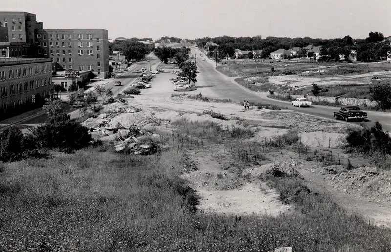
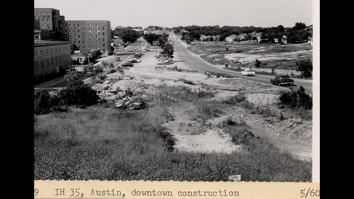
3) 12th Street I-35 Construction, 1960
Taken from what used to be a bluff over Waller Creek, where today’s main lanes pass under 11th and 12th streets. The building on the left? That’s the old Brackenridge Hospital.
4) Building the Upper Deck in 1973
Snapped near Hancock Center at 41st Street during the construction of the upper deck.

5) I-35 at riverside drive, 157
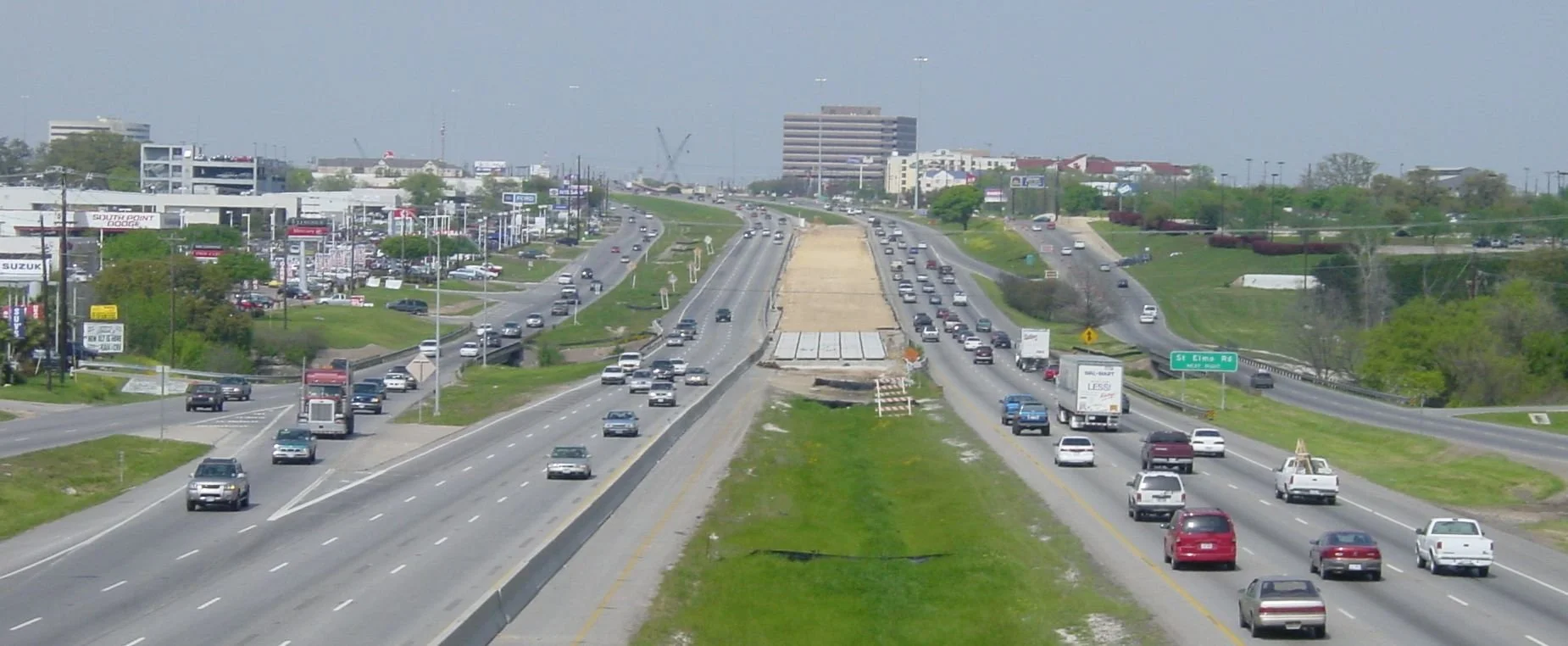
The curve approaching the river and Downtown from the south—now one of the most congested stretches on I-35 between Minnesota and Mexico.

6) view from 19th street (MLK blvd), looking south
Another look at the old Brackenridge Hospital, which, at the time, was the tallest building anywhere near the highway.

7) before i-35: east avenue
From nearly the same spot as the previous image. East Avenue was once a residential boulevard, but it also marked Austin’s racial divide between east and west.
MORE HISTORICAL PHOTOS OF I-35 THROUGH AUSTIN


Check this out!
I-35 Expansion - Properties taken by Eminent Domain for the expansion
READ
Dive into our top blog articles
East Austin “State Of The Market”
East Austin Temperature Gauge : sign up to receive exclusive monthly reports to gauge commercial real estate leasing, sales, and development activity. Created specifically for East Austin Commercial Real Estate owners.
meet
Join our in-person events
PAST EVENTS


gallery

east austin 111 year old building

